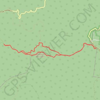
Northbrook Mountain Loop
Interactive trail map
Trail profile
- Distance: 11.2 Km
- Elevation gain: 602 m
- Maximum elevation: 706 m
- Elevation loss: 602 m
- Minimum elevation: 452 m
About this trail
Name: Northbrook Mountain Loop trail, distance, elevation, map, profile, GPS track
Coordinates: -27.32426 152.70637 -27.31801 152.75025
Topography: City of Brisbane topographic map, elevation, terrain
Other hiking, mountain biking, running and outdoor activity trails
Click on a trail to view its statistics, map and profile.
Northbrook Mountain, England Creek and back up via Joyners Break
Distance: 40.1 Km • Elevation gain: 1,749 m • Maximum elevation: 706 m
Northbrook Mountain & Gorge
Loop run / trail / hike via Northbrook Parkway, Wivenhoe Outlook, Switchback Road, Cattleyards Break, England Creek Road, Northbrook Mountain bush Camp, Northbrook Mountain, Lawton Road and Northbrook Gorge Trail in d'Aguilar National Park. #Running #Trail #Hiking #Mountain #Nature #Forest #Park
Distance: 24.5 Km • Elevation gain: 1,271 m • Maximum elevation: 624 m