Bulle and its surrounding castles – Shortened alternative
Would you like to discover the Châteaux of Bulle and Gruyères by bike ?
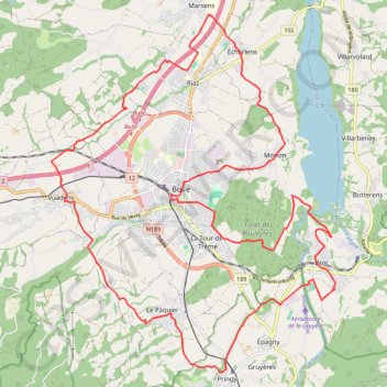
- Distance: 32.4 Km
- Elevation gain: 477 m
- Maximum elevation: 874 m
- Elevation loss: 477 m
- Minimum elevation: 681 m
Interactive trail map
Trail profile
- Distance: 32.4 Km
- Elevation gain: 477 m
- Maximum elevation: 874 m
- Elevation loss: 477 m
- Minimum elevation: 681 m
About this trail
Name: Bulle and its surrounding castles – Shortened alternative trail, distance, elevation, map, profile, GPS track
Coordinates: 46.58250 7.02049 46.65380 7.10302
Other hiking, mountain biking, running and outdoor activity trails
Click on a trail to view its statistics, map and profile.
PT23DS2 Lörrach → Cadaqués
Germany > Baden-Württemberg > Landkreis Lörrach > Lörrach (Kernstadt)
Distance: 1,050.7 Km • Elevation gain: 13,130 m • Maximum elevation: 1,505 m