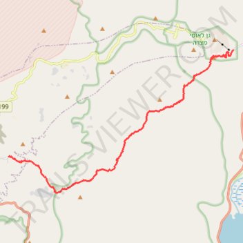
Mesada - Arad
מצדה לערד: קו ארוך לרוחב מדבר יהודה
- Distance: 19.0 Km
- Elevation gain: 1,219 m
- Maximum elevation: 577 m
- Elevation loss: 348 m
- Minimum elevation: -297 m
- Moving time: 6 h 17 m
- Moving speed: 3.0 Km/h
- Maximum speed: 4.1 Km/h
- Total time: 6 h 17 m
- Global speed: 3.0 Km/h
Interactive trail map
Trail profile
- Distance: 19.0 Km
- Elevation gain: 1,219 m
- Maximum elevation: 577 m
- Elevation loss: 348 m
- Minimum elevation: -297 m
- Moving time: 6 h 17 m
- Moving speed: 3.0 Km/h
- Maximum speed: 4.1 Km/h
- Total time: 6 h 17 m
- Global speed: 3.0 Km/h
About this trail
Name: Mesada - Arad trail, distance, elevation, map, profile, GPS track
Start: Tamar Regional Council, Beersheba Subdistrict, South District, Israel (31.31244 35.36438)
End: Moab, Arad, Beersheba Subdistrict, South District, Israel (31.26132 35.23943)
Coordinates: 31.24427 35.23939 31.31244 35.36438
Other hiking, mountain biking, running and outdoor activity trails
Click on a trail to view its statistics, map and profile.
7 Ascents in the Dead Sea
Israel > South District > Tamar Regional Council
שבע מעלות בים המלח: קו עליות דרך עשאל, משמר, צאלים ומצדה
Distance: 31.2 Km • Elevation gain: 2,112 m • Maximum elevation: 275 m