Import a GPX file

Hobart Ride

#Bike #Loop #Tasmania

  • Distance: 17.0 Km
  • Elevation gain: 278 m
  • Maximum elevation: 71 m
  • Elevation loss: 277 m
  • Minimum elevation: 4 m

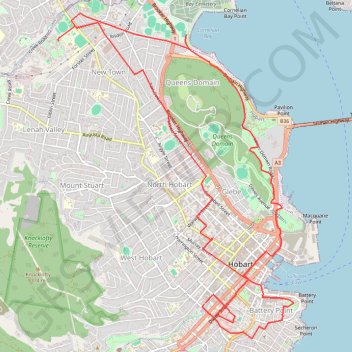
Interactive trail map

Trail profile

  • Distance: 17.0 Km
  • Elevation gain: 278 m
  • Maximum elevation: 71 m
  • Elevation loss: 277 m
  • Minimum elevation: 4 m
👉 Easily get elevation data in JSON, GeoTIFF and KML formats using Elevation API
Thank you for supporting this site ❤️
Make a donation

Gear up for your next adventure:

As an Amazon Associate, this site earns from qualifying purchases at no extra cost to you.

About this trail

Other hiking, mountain biking, running and outdoor activity trails

Click on a trail to view its statistics, map and profile.

South Hobart - Glenlusk - Derwent River - Moelsworth

Australia > Tasmania > Hobart

#Bike #Loop #Tasmania

Distance: 68.8 Km • Elevation gain: 1,092 m • Maximum elevation: 434 m

South Hobart - Howrah - Bowen Bridge

Australia > Tasmania > Hobart

#Bike #Loop #Tasmania

Distance: 49.9 Km • Elevation gain: 599 m • Maximum elevation: 72 m

Hobart - Mount Field Loop

Australia > Tasmania > Hobart

#Bike #Loop #Tasmania

Distance: 204.9 Km • Elevation gain: 2,722 m • Maximum elevation: 460 m

Ross - Hobart

Australia > Tasmania > Ross

#Bike #Tasmania

Distance: 159.2 Km • Elevation gain: 2,267 m • Maximum elevation: 552 m

Gear up for your next adventure:

🎨Portable Watercolor Kits - Paint the landscapes and topographic views you discover
🐍Snake Gaiters - Protection against snake bites
👟Lightweight Trail Runners - Agile footwear for fast movement over rugged Australian terrain
🍴Titanium Spork & Cutlery - Indestructible and feather-light eating utensils
🏃Compression Recovery Socks - Reduce leg fatigue after heavy days of elevation gain

As an Amazon Associate, this site earns from qualifying purchases at no extra cost to you.