Baker Ridge
Ski touring. #Ski #SkiTouring
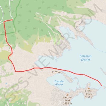
- Distance: 8.0 Km
- Elevation gain: 1,629 m
- Maximum elevation: 2,746 m
- Elevation loss: 16 m
- Minimum elevation: 1,132 m
Interactive trail map
Trail profile
- Distance: 8.0 Km
- Elevation gain: 1,629 m
- Maximum elevation: 2,746 m
- Elevation loss: 16 m
- Minimum elevation: 1,132 m
About this trail
Name: Baker Ridge trail, distance, elevation, map, profile, GPS track
End: Coleman-Deming Route, Whatcom County, Washington, United States (48.77234 -121.83491)
Coordinates: 48.77234 -121.90161 48.80200 -121.83491
Other hiking, mountain biking, running and outdoor activity trails
Click on a trail to view its statistics, map and profile.
Mount Baker via Heliotrope Ridge Trail and Coleman-Deming Route
United States > Washington > Whatcom County
The Heliotrope Ridge Trail, followed by the Coleman-Deming Route, offers hikers and mountaineers a unique blend of challenging terrain and breathtaking vistas as they approach Mount Baker’s summit. As you ascend, the trail takes you past scenic alpine meadows and views of towering glaciers, particularly the…
Distance: 10.3 Km • Elevation gain: 2,166 m • Maximum elevation: 3,267 m
Northern part of the Pacific Crest Trail (PCT)
United States > Oregon > Klamath County
Hike on the Pacific Crest National Scenic Trail from Crater Lake to Canada Border through Oregon and Washington along the Sierra Nevada and Cascade mountain ranges. #Hiking #Mountain #SierraNevada #Cascade #Nature #Forest #Park #PCT
Distance: 1,198.3 Km • Elevation gain: 44,308 m • Maximum elevation: 2,307 m