Make a donation
Gear up for your next adventure:
As an Amazon Associate, this site earns from qualifying purchases at no extra cost to you.
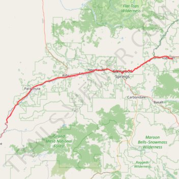
2026-01-14_13-18_Wed
- Distance: 143.8 Km
- Elevation gain: 1,689 m
- Maximum elevation: 2,032 m
- Elevation loss: 1,186 m
- Minimum elevation: 1,471 m
Interactive trail map
Make a donation
Gear up for your next adventure:
As an Amazon Associate, this site earns from qualifying purchases at no extra cost to you.
Trail profile
- Distance: 143.8 Km
- Elevation gain: 1,689 m
- Maximum elevation: 2,032 m
- Elevation loss: 1,186 m
- Minimum elevation: 1,471 m
Make a donation
Gear up for your next adventure:
As an Amazon Associate, this site earns from qualifying purchases at no extra cost to you.
About this trail
Name: 2026-01-14_13-18_Wed trail, distance, elevation, map, profile, GPS track
End: Tesla, 550, Plane Street, Gypsum, Eagle County, Colorado, 81637, United States (39.63776 -106.92067)
Coordinates: 39.23876 -108.25963 39.65324 -106.91999
Make a donation
Gear up for your next adventure:
As an Amazon Associate, this site earns from qualifying purchases at no extra cost to you.
Other hiking, mountain biking, running and outdoor activity trails
Click on a trail to view its statistics, map and profile.
Hanging Lake Trail in White River National Forest
United States > Colorado > Garfield County
The Hanging Lake Trail offers an unforgettable hiking experience in Colorado's White River National Forest. The route follows a scenic canyon, with lush greenery and multiple footbridges crossing over Dead Horse Creek, leading to the striking turquoise lake. As you reach the top, you're rewarded with a…
Distance: 2.2 Km • Elevation gain: 331 m • Maximum elevation: 2,199 m
Burning Mountain loop via Ward Peak and Fire in the Mountain trails
United States > Colorado > Garfield County > New Castle
Distance: 16.8 Km • Elevation gain: 739 m • Maximum elevation: 2,179 m
2026-02-14_14-17_Sat
United States > Colorado > Mesa County
Distance: 139.8 Km • Elevation gain: 2,215 m • Maximum elevation: 2,460 m
Make a donation
Gear up for your next adventure:
As an Amazon Associate, this site earns from qualifying purchases at no extra cost to you.