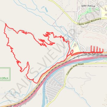
Burning Mountain loop via Ward Peak and Fire in the Mountain trails
- Distance: 16.8 Km
- Elevation gain: 739 m
- Maximum elevation: 2,179 m
- Elevation loss: 739 m
- Minimum elevation: 1,693 m
- Moving time: 1 h 54 m
- Moving speed: 8.8 Km/h
- Maximum speed: 43.5 Km/h
- Total time: 2 h 20 s
- Global speed: 8.4 Km/h
Interactive trail map
Trail profile
- Distance: 16.8 Km
- Elevation gain: 739 m
- Maximum elevation: 2,179 m
- Elevation loss: 739 m
- Minimum elevation: 1,693 m
- Moving time: 1 h 54 m
- Moving speed: 8.8 Km/h
- Maximum speed: 43.5 Km/h
- Total time: 2 h 20 s
- Global speed: 8.4 Km/h
About this trail
Name: Burning Mountain loop via Ward Peak and Fire in the Mountain trails trail, distance, elevation, map, profile, GPS track
Coordinates: 39.56334 -107.56534 39.57909 -107.53135