Diamond Lake
Interactive trail map
Trail profile
- Distance: 8.7 Km
- Elevation gain: 414 m
- Maximum elevation: 3,349 m
- Elevation loss: 415 m
- Minimum elevation: 3,090 m
About this trail
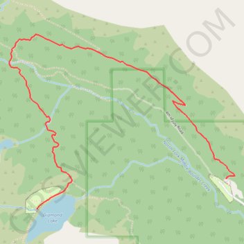
Name: Diamond Lake trail, distance, elevation, map, profile, GPS track
Coordinates: 39.99307 -105.65393 40.00514 -105.63354
Other hiking, mountain biking, running and outdoor activity trails
Click on a trail to view its statistics, map and profile.
Route to Mount Neva in Roosevelt National Forest via Arapaho Pass Trail and Neva Lakes
United States > Colorado > Boulder County
Distance: 14.7 Km • Elevation gain: 965 m • Maximum elevation: 3,905 m