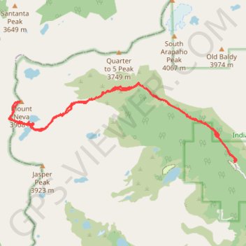
Route to Mount Neva in Roosevelt National Forest via Arapaho Pass Trail and Neva Lakes
- Distance: 14.7 Km
- Elevation gain: 965 m
- Maximum elevation: 3,905 m
- Elevation loss: 965 m
- Minimum elevation: 3,090 m
- Moving time: 4 h 40 m
- Moving speed: 3.1 Km/h
- Maximum speed: 5.7 Km/h
- Total time: 5 h 37 m
- Global speed: 2.6 Km/h
Interactive trail map
Trail profile
- Distance: 14.7 Km
- Elevation gain: 965 m
- Maximum elevation: 3,905 m
- Elevation loss: 965 m
- Minimum elevation: 3,090 m
- Moving time: 4 h 40 m
- Moving speed: 3.1 Km/h
- Maximum speed: 5.7 Km/h
- Total time: 5 h 37 m
- Global speed: 2.6 Km/h
About this trail
Name: Route to Mount Neva in Roosevelt National Forest via Arapaho Pass Trail and Neva Lakes trail, distance, elevation, map, profile, GPS track
Start: Arapaho Pass Trail, Boulder County, Colorado, United States (39.99502 -105.63393)
End: Arapaho Pass Trail, Boulder County, Colorado, United States (39.99502 -105.63394)
Coordinates: 39.99502 -105.69133 40.01044 -105.63354
Other hiking, mountain biking, running and outdoor activity trails
Click on a trail to view its statistics, map and profile.