Make a donation
Gear up for your next adventure:
As an Amazon Associate, this site earns from qualifying purchases at no extra cost to you.
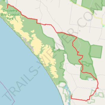
Great Southern West Walk - Swan Lake to Tarragal Caves
- Distance: 28.2 Km
- Elevation gain: 398 m
- Maximum elevation: 216 m
- Elevation loss: 392 m
- Minimum elevation: 7 m
- Moving time: 6 h 24 m
- Moving speed: 4.4 Km/h
- Maximum speed: 9.0 Km/h
- Total time: 6 h 52 m
- Global speed: 4.1 Km/h
Interactive trail map
Make a donation
Gear up for your next adventure:
As an Amazon Associate, this site earns from qualifying purchases at no extra cost to you.
Trail profile
- Distance: 28.2 Km
- Elevation gain: 398 m
- Maximum elevation: 216 m
- Elevation loss: 392 m
- Minimum elevation: 7 m
- Moving time: 6 h 24 m
- Moving speed: 4.4 Km/h
- Maximum speed: 9.0 Km/h
- Total time: 6 h 52 m
- Global speed: 4.1 Km/h
Make a donation
Gear up for your next adventure:
As an Amazon Associate, this site earns from qualifying purchases at no extra cost to you.
About this trail
Name: Great Southern West Walk - Swan Lake to Tarragal Caves trail, distance, elevation, map, profile, GPS track
Start: Swan Lake Road, Mount Richmond, Shire of Glenelg, Victoria, 3305, Australia (-38.21635 141.31108)
Coordinates: -38.32495 141.31108 -38.21124 141.44771
Topography: Victoria topographic map, elevation, terrain
Make a donation
Gear up for your next adventure:
As an Amazon Associate, this site earns from qualifying purchases at no extra cost to you.
Other hiking, mountain biking, running and outdoor activity trails
Click on a trail to view its statistics, map and profile.
Great Southern West Walk Section (Tarragal Caves to Shelly Beach)
Distance: 22.1 Km • Elevation gain: 763 m • Maximum elevation: 126 m