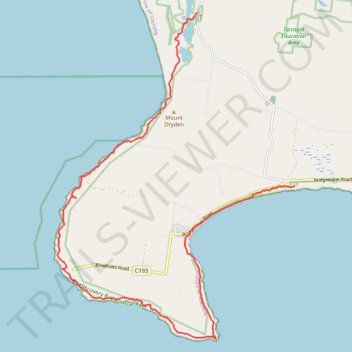
Great Southern West Walk Section (Tarragal Caves to Shelly Beach)
- Distance: 22.1 Km
- Elevation gain: 763 m
- Maximum elevation: 126 m
- Elevation loss: 757 m
- Minimum elevation: 0 m
- Moving time: 5 h 18 m
- Moving speed: 4.2 Km/h
- Maximum speed: 9.4 Km/h
- Total time: 6 h 24 m
- Global speed: 3.5 Km/h
Interactive trail map
Trail profile
- Distance: 22.1 Km
- Elevation gain: 763 m
- Maximum elevation: 126 m
- Elevation loss: 757 m
- Minimum elevation: 0 m
- Moving time: 5 h 18 m
- Moving speed: 4.2 Km/h
- Maximum speed: 9.4 Km/h
- Total time: 6 h 24 m
- Global speed: 3.5 Km/h
About this trail
Name: Great Southern West Walk Section (Tarragal Caves to Shelly Beach) trail, distance, elevation, map, profile, GPS track
Coordinates: -38.39583 141.36498 -38.31835 141.43698
Topography: Victoria topographic map, elevation, terrain
Other hiking, mountain biking, running and outdoor activity trails
Click on a trail to view its statistics, map and profile.
Great Southern West Walk - Swan Lake to Tarragal Caves
Distance: 28.2 Km • Elevation gain: 398 m • Maximum elevation: 216 m