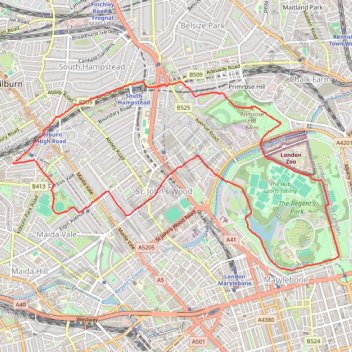
St John's Wood Loop
Loop walk through St John's Wood via Primrose Hill, Regent's Park, Abbey Road and Paddington Recreation Ground. #Walking #Hiking #Loop #City #Park #Nature
- Distance: 10.7 Km
- Elevation gain: 99 m
- Maximum elevation: 62 m
- Elevation loss: 99 m
- Minimum elevation: 26 m
- Moving time: 1 h 44 m
- Moving speed: 6.1 Km/h
- Maximum speed: 9.8 Km/h
- Total time: 1 h 45 m
- Global speed: 6.1 Km/h
Interactive trail map
Trail profile
- Distance: 10.7 Km
- Elevation gain: 99 m
- Maximum elevation: 62 m
- Elevation loss: 99 m
- Minimum elevation: 26 m
- Moving time: 1 h 44 m
- Moving speed: 6.1 Km/h
- Maximum speed: 9.8 Km/h
- Total time: 1 h 45 m
- Global speed: 6.1 Km/h
About this trail
Name: St John's Wood Loop trail, distance, elevation, map, profile, GPS track
Coordinates: 51.52411 -0.19716 51.54202 -0.14741
Other hiking, mountain biking, running and outdoor activity trails
Click on a trail to view its statistics, map and profile.
2014-07-29 06:09:07 Auto
United Kingdom > England > London
Distance: 60.8 Km • Elevation gain: 307 m • Maximum elevation: 38 m
Night Run
United Kingdom > England > London
Distance: 11.0 Km • Elevation gain: 73 m • Maximum elevation: 42 m