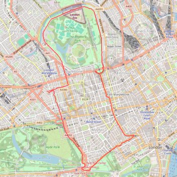
Night Run
- Distance: 11.0 Km
- Elevation gain: 73 m
- Maximum elevation: 42 m
- Elevation loss: 73 m
- Minimum elevation: 17 m
- Moving time: 59 m 55 s
- Moving speed: 11.0 Km/h
- Maximum speed: 23.5 Km/h
- Total time: 59 m 55 s
- Global speed: 11.0 Km/h
Interactive trail map
Trail profile
- Distance: 11.0 Km
- Elevation gain: 73 m
- Maximum elevation: 42 m
- Elevation loss: 73 m
- Minimum elevation: 17 m
- Moving time: 59 m 55 s
- Moving speed: 11.0 Km/h
- Maximum speed: 23.5 Km/h
- Total time: 59 m 55 s
- Global speed: 11.0 Km/h
About this trail
Name: Night Run trail, distance, elevation, map, profile, GPS track
Coordinates: 51.50261 -0.16538 51.53679 -0.13493
Other hiking, mountain biking, running and outdoor activity trails
Click on a trail to view its statistics, map and profile.
2014-07-29 06:09:07 Auto
United Kingdom > England > London
Distance: 60.8 Km • Elevation gain: 307 m • Maximum elevation: 38 m
London Marathon
United Kingdom > England > London
Distance: 42.2 Km • Elevation gain: 281 m • Maximum elevation: 50 m