Make a donation
Gear up for your next adventure:
As an Amazon Associate, this site earns from qualifying purchases at no extra cost to you.
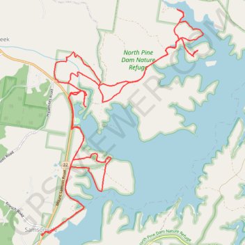
Kobble Creek - Lake Samsonvale
North Pine Dam Nature Reserve. #MTB #Loop #NorthPine #Kobble #Samsonvale
- Distance: 24.1 Km
- Elevation gain: 292 m
- Maximum elevation: 75 m
- Elevation loss: 292 m
- Minimum elevation: 39 m
Interactive trail map
Make a donation
Gear up for your next adventure:
As an Amazon Associate, this site earns from qualifying purchases at no extra cost to you.
Trail profile
- Distance: 24.1 Km
- Elevation gain: 292 m
- Maximum elevation: 75 m
- Elevation loss: 292 m
- Minimum elevation: 39 m
Make a donation
Gear up for your next adventure:
As an Amazon Associate, this site earns from qualifying purchases at no extra cost to you.
About this trail
Name: Kobble Creek - Lake Samsonvale trail, distance, elevation, map, profile, GPS track
Coordinates: -27.28246 152.84522 -27.24080 152.87870
Topography: Queensland topographic map, elevation, terrain
Make a donation
Gear up for your next adventure:
As an Amazon Associate, this site earns from qualifying purchases at no extra cost to you.
Other hiking, mountain biking, running and outdoor activity trails
Click on a trail to view its statistics, map and profile.
Make a donation
Gear up for your next adventure:
As an Amazon Associate, this site earns from qualifying purchases at no extra cost to you.