Thank you for supporting this site ❤️
Make a donation
Make a donation
Gear up for your next adventure:
As an Amazon Associate, this site earns from qualifying purchases at no extra cost to you.
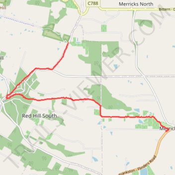
Red Hill to Merricks rail trail walk
- Distance: 9.8 Km
- Elevation gain: 117 m
- Maximum elevation: 213 m
- Elevation loss: 226 m
- Minimum elevation: 43 m
- Moving time: 1 h 34 m
- Moving speed: 6.2 Km/h
- Maximum speed: 19.3 Km/h
- Total time: 1 h 34 m
- Global speed: 6.2 Km/h
Interactive trail map
Thank you for supporting this site ❤️
Make a donation
Make a donation
Gear up for your next adventure:
As an Amazon Associate, this site earns from qualifying purchases at no extra cost to you.
Trail profile
- Distance: 9.8 Km
- Elevation gain: 117 m
- Maximum elevation: 213 m
- Elevation loss: 226 m
- Minimum elevation: 43 m
- Moving time: 1 h 34 m
- Moving speed: 6.2 Km/h
- Maximum speed: 19.3 Km/h
- Total time: 1 h 34 m
- Global speed: 6.2 Km/h
Thank you for supporting this site ❤️
Make a donation
Make a donation
Gear up for your next adventure:
As an Amazon Associate, this site earns from qualifying purchases at no extra cost to you.
About this trail
Name: Red Hill to Merricks rail trail walk trail, distance, elevation, map, profile, GPS track
Coordinates: -38.39097 145.02548 -38.36392 145.08826
Topography: Melbourne topographic map, elevation, terrain
Thank you for supporting this site ❤️
Make a donation
Make a donation
Gear up for your next adventure:
🎒40L Day Hiking Backpacks - Comfortable packs with hydration support for long days exploring topographic peaks
As an Amazon Associate, this site earns from qualifying purchases at no extra cost to you.
Other hiking, mountain biking, running and outdoor activity trails
Click on a trail to view its statistics, map and profile.
Merricks to Red Hill rail trail walk
Australia > Victoria > Melbourne > Merricks
Distance: 10.1 Km • Elevation gain: 235 m • Maximum elevation: 214 m