Thank you for supporting this site ❤️
Make a donation
Make a donation
Gear up for your next adventure:
As an Amazon Associate, this site earns from qualifying purchases at no extra cost to you.
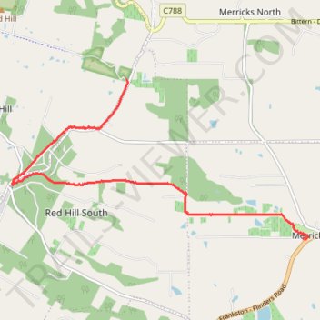
Merricks to Red Hill rail trail walk
- Distance: 10.1 Km
- Elevation gain: 235 m
- Maximum elevation: 214 m
- Elevation loss: 129 m
- Minimum elevation: 43 m
- Moving time: 1 h 39 m
- Moving speed: 6.1 Km/h
- Maximum speed: 21.9 Km/h
- Total time: 1 h 41 m
- Global speed: 6.0 Km/h
Interactive trail map
Thank you for supporting this site ❤️
Make a donation
Make a donation
Gear up for your next adventure:
As an Amazon Associate, this site earns from qualifying purchases at no extra cost to you.
Trail profile
- Distance: 10.1 Km
- Elevation gain: 235 m
- Maximum elevation: 214 m
- Elevation loss: 129 m
- Minimum elevation: 43 m
- Moving time: 1 h 39 m
- Moving speed: 6.1 Km/h
- Maximum speed: 21.9 Km/h
- Total time: 1 h 41 m
- Global speed: 6.0 Km/h
Thank you for supporting this site ❤️
Make a donation
Make a donation
Gear up for your next adventure:
As an Amazon Associate, this site earns from qualifying purchases at no extra cost to you.
About this trail
Name: Merricks to Red Hill rail trail walk trail, distance, elevation, map, profile, GPS track
Coordinates: -38.39060 145.02440 -38.36371 145.08826
Topography: Melbourne topographic map, elevation, terrain
Thank you for supporting this site ❤️
Make a donation
Make a donation
Gear up for your next adventure:
As an Amazon Associate, this site earns from qualifying purchases at no extra cost to you.
Other hiking, mountain biking, running and outdoor activity trails
Click on a trail to view its statistics, map and profile.
Red Hill to Merricks rail trail walk
Australia > Victoria > Melbourne > Red Hill
Distance: 9.8 Km • Elevation gain: 117 m • Maximum elevation: 213 m