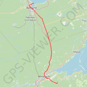
Bathurst - Black River Bridge
#Bike #Bathurst #BlackRiverBridge
- Distance: 99.9 Km
- Elevation gain: 656 m
- Maximum elevation: 163 m
- Elevation loss: 629 m
- Minimum elevation: -2 m
Interactive trail map
Trail profile
- Distance: 99.9 Km
- Elevation gain: 656 m
- Maximum elevation: 163 m
- Elevation loss: 629 m
- Minimum elevation: -2 m
About this trail
Name: Bathurst - Black River Bridge trail, distance, elevation, map, profile, GPS track
Coordinates: 46.96902 -65.68305 47.66431 -65.32072
Other hiking, mountain biking, running and outdoor activity trails
Click on a trail to view its statistics, map and profile.
Black River Bridge - Shédiac
Canada > New Brunswick > Glenelg Parish
Gulf of Saint Lawrence. #Bike #SaintLawrence #Atlantic
Distance: 114.8 Km • Elevation gain: 451 m • Maximum elevation: 37 m
Campbellton - Bathurst
Canada > Quebec > Avignon > Pointe-à-la-Croix > Cross Point Station
Ristigouche River. Gulf of Saint Lawrence. #Bike #Campbellton #Bathurst #Ristigouche #SaintLawrence
Distance: 119.2 Km • Elevation gain: 668 m • Maximum elevation: 69 m
Sentier Nepisiguit vers les chutes Pabineau
Canada > New Brunswick > Chaleur Rural District > Bathurst Parish > Pabineau First Nation
Distance: 3.3 Km • Elevation gain: 35 m • Maximum elevation: 45 m