Black River Bridge - Shédiac
Gulf of Saint Lawrence. #Bike #SaintLawrence #Atlantic
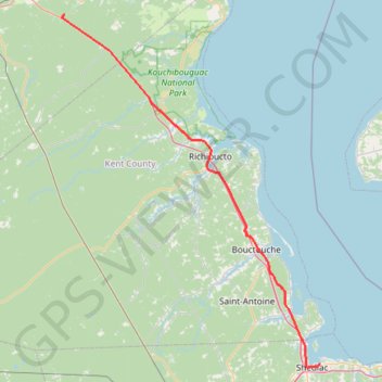
- Distance: 114.8 Km
- Elevation gain: 451 m
- Maximum elevation: 37 m
- Elevation loss: 470 m
- Minimum elevation: -1 m
Interactive trail map
Trail profile
- Distance: 114.8 Km
- Elevation gain: 451 m
- Maximum elevation: 37 m
- Elevation loss: 470 m
- Minimum elevation: -1 m
About this trail
Name: Black River Bridge - Shédiac trail, distance, elevation, map, profile, GPS track
Coordinates: 46.21723 -65.32969 46.97725 -64.52304
Other hiking, mountain biking, running and outdoor activity trails
Click on a trail to view its statistics, map and profile.
Bathurst - Black River Bridge
Canada > New Brunswick > Bathurst Parish > Bathurst
#Bike #Bathurst #BlackRiverBridge
Distance: 99.9 Km • Elevation gain: 656 m • Maximum elevation: 163 m
Sentier de la Sagouine à la Marina
Canada > New Brunswick > Wellington Parish > Bouctouche
Distance: 0.6 Km • Elevation gain: 19 m • Maximum elevation: 21 m