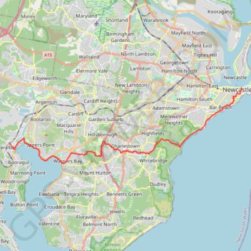
Teralba - Newcastle
- Distance: 25.4 Km
- Elevation gain: 363 m
- Maximum elevation: 107 m
- Elevation loss: 375 m
- Minimum elevation: -1 m
Interactive trail map
Trail profile
- Distance: 25.4 Km
- Elevation gain: 363 m
- Maximum elevation: 107 m
- Elevation loss: 375 m
- Minimum elevation: -1 m
About this trail
Name: Teralba - Newcastle trail, distance, elevation, map, profile, GPS track
Coordinates: -32.97539 151.60369 -32.92632 151.78488
Topography: Newcastle-Maitland topographic map, elevation, terrain
Other hiking, mountain biking, running and outdoor activity trails
Click on a trail to view its statistics, map and profile.
Broadmeadow - Readhead Beach - Belmont
Australia > New South Wales > Newcastle-Maitland
Fernleigh Track. #Bike
Distance: 36.8 Km • Elevation gain: 264 m • Maximum elevation: 98 m
Fernleigh Rail Trail
Australia > New South Wales > Newcastle-Maitland > Belmont
#Bike
Distance: 21.1 Km • Elevation gain: 160 m • Maximum elevation: 98 m
Borehole Colliery No.1 site
Australia > New South Wales > Newcastle-Maitland
Distance: 4.2 Km • Elevation gain: 124 m • Maximum elevation: 96 m