Glenrock State Conservation Area Loop
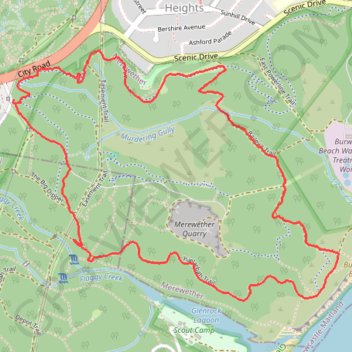
Interactive trail map
Trail profile
- Distance: 6.5 Km
- Elevation gain: 174 m
- Maximum elevation: 108 m
- Elevation loss: 175 m
- Minimum elevation: 21 m
- Moving time: 1 h 28 m
- Moving speed: 4.4 Km/h
- Maximum speed: 6.8 Km/h
- Total time: 1 h 32 m
- Global speed: 4.2 Km/h
About this trail
Name: Glenrock State Conservation Area Loop trail, distance, elevation, map, profile, GPS track
Coordinates: -32.96089 151.72231 -32.94928 151.74036
Topography: Newcastle topographic map, elevation, terrain
Other hiking, mountain biking, running and outdoor activity trails
Click on a trail to view its statistics, map and profile.
Broadmeadow - Readhead Beach - Belmont
Australia > New South Wales > Newcastle-Maitland
Fernleigh Track. #Bike
Distance: 36.8 Km • Elevation gain: 264 m • Maximum elevation: 98 m
Teralba - Newcastle
Australia > New South Wales > Newcastle-Maitland
Distance: 25.4 Km • Elevation gain: 363 m • Maximum elevation: 107 m
Fernleigh Rail Trail
Australia > New South Wales > Newcastle-Maitland > Belmont
#Bike
Distance: 21.1 Km • Elevation gain: 160 m • Maximum elevation: 98 m
Borehole Colliery No.1 site
Australia > New South Wales > Newcastle-Maitland
Distance: 4.2 Km • Elevation gain: 124 m • Maximum elevation: 96 m