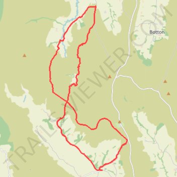
Church Houses Loop Mountain Biking
- Distance: 23.1 Km
- Elevation gain: 645 m
- Maximum elevation: 393 m
- Elevation loss: 645 m
- Minimum elevation: 140 m
- Moving time: 1 h 55 m
- Moving speed: 12.0 Km/h
- Maximum speed: 44.6 Km/h
- Total time: 2 h 35 m
- Global speed: 8.9 Km/h
Interactive trail map
Trail profile
- Distance: 23.1 Km
- Elevation gain: 645 m
- Maximum elevation: 393 m
- Elevation loss: 645 m
- Minimum elevation: 140 m
- Moving time: 1 h 55 m
- Moving speed: 12.0 Km/h
- Maximum speed: 44.6 Km/h
- Total time: 2 h 35 m
- Global speed: 8.9 Km/h
About this trail
Name: Church Houses Loop Mountain Biking trail, distance, elevation, map, profile, GPS track
Coordinates: 54.36870 -1.00696 54.43824 -0.95018
Other hiking, mountain biking, running and outdoor activity trails
Click on a trail to view its statistics, map and profile.
Rosedale Abbey north loop to Fryup Dale
United Kingdom > England > North Yorkshire > Rosedale Abbey
Distance: 31.9 Km • Elevation gain: 701 m • Maximum elevation: 422 m
Westerdale Kildale Loop
United Kingdom > England > North Yorkshire > Westerdale
Scarborough Mountain Biking
Distance: 19.5 Km • Elevation gain: 606 m • Maximum elevation: 341 m
Westerdale top
United Kingdom > England > North Yorkshire > Westerdale
Mountain Biking
Distance: 27.4 Km • Elevation gain: 663 m • Maximum elevation: 422 m
Farndale
United Kingdom > England > North Yorkshire > Appleton-le-Moors
Ryedale Mountain Biking
Distance: 52.9 Km • Elevation gain: 1,251 m • Maximum elevation: 407 m