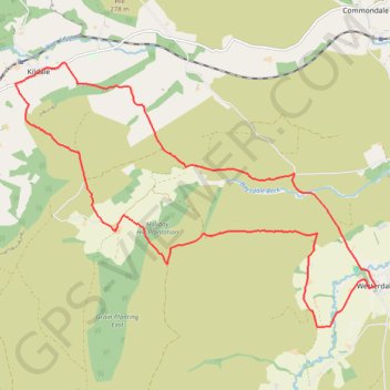
Westerdale Kildale Loop
Scarborough Mountain Biking
- Distance: 19.5 Km
- Elevation gain: 606 m
- Maximum elevation: 341 m
- Elevation loss: 606 m
- Minimum elevation: 150 m
- Moving time: 1 h 43 m
- Moving speed: 11.3 Km/h
- Maximum speed: 51.0 Km/h
- Total time: 2 h 14 m
- Global speed: 8.7 Km/h
Interactive trail map
Trail profile
- Distance: 19.5 Km
- Elevation gain: 606 m
- Maximum elevation: 341 m
- Elevation loss: 606 m
- Minimum elevation: 150 m
- Moving time: 1 h 43 m
- Moving speed: 11.3 Km/h
- Maximum speed: 51.0 Km/h
- Total time: 2 h 14 m
- Global speed: 8.7 Km/h
About this trail
Name: Westerdale Kildale Loop trail, distance, elevation, map, profile, GPS track
Coordinates: 54.43766 -1.06996 54.47760 -0.97629
Other hiking, mountain biking, running and outdoor activity trails
Click on a trail to view its statistics, map and profile.
Church Houses Loop Mountain Biking
United Kingdom > England > North Yorkshire > Church Houses
Distance: 23.1 Km • Elevation gain: 645 m • Maximum elevation: 393 m
Westerdale top
United Kingdom > England > North Yorkshire > Westerdale
Mountain Biking
Distance: 27.4 Km • Elevation gain: 663 m • Maximum elevation: 422 m