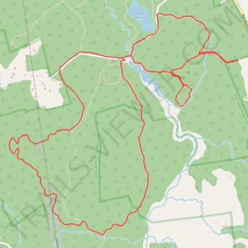
Pachaug Hodge Pond Large Loop
- Distance: 10.6 Km
- Elevation gain: 219 m
- Maximum elevation: 154 m
- Elevation loss: 219 m
- Minimum elevation: 70 m
- Moving time: 2 h 31 m
- Moving speed: 4.2 Km/h
- Maximum speed: 7.7 Km/h
- Total time: 3 h 22 m
- Global speed: 3.2 Km/h
Interactive trail map
Trail profile
- Distance: 10.6 Km
- Elevation gain: 219 m
- Maximum elevation: 154 m
- Elevation loss: 219 m
- Minimum elevation: 70 m
- Moving time: 2 h 31 m
- Moving speed: 4.2 Km/h
- Maximum speed: 7.7 Km/h
- Total time: 3 h 22 m
- Global speed: 3.2 Km/h
About this trail
Name: Pachaug Hodge Pond Large Loop trail, distance, elevation, map, profile, GPS track
Coordinates: 41.52567 -71.87098 41.54556 -71.84346
Other hiking, mountain biking, running and outdoor activity trails
Click on a trail to view its statistics, map and profile.
Loop hike from Kinne Cemetery - Pachaug State Park
United States > Connecticut > Northeastern Connecticut Planning Region > Voluntown
Distance: 6.5 Km • Elevation gain: 122 m • Maximum elevation: 154 m