Mutley Park, Thorn Park
- Distance: 0.8 Km
- Elevation gain: 29 m
- Maximum elevation: 99 m
- Elevation loss: 0 m
- Minimum elevation: 69 m
- Moving time: 15 m 27 s
- Moving speed: 3.1 Km/h
- Maximum speed: 6.2 Km/h
- Total time: 16 m 23 s
- Global speed: 2.9 Km/h
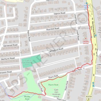
Interactive trail map
Trail profile
- Distance: 0.8 Km
- Elevation gain: 29 m
- Maximum elevation: 99 m
- Elevation loss: 0 m
- Minimum elevation: 69 m
- Moving time: 15 m 27 s
- Moving speed: 3.1 Km/h
- Maximum speed: 6.2 Km/h
- Total time: 16 m 23 s
- Global speed: 2.9 Km/h
About this trail
Name: Mutley Park, Thorn Park trail, distance, elevation, map, profile, GPS track
Start: 1, Trelorrin Gardens, Mutley, Plymouth, England, PL3 4BT, United Kingdom (50.38763 -4.13572)
End: Mannamead Road, Hartley, Plymouth, England, PL3 5NL, United Kingdom (50.39125 -4.13075)
Coordinates: 50.38755 -4.13572 50.39125 -4.13046
Other hiking, mountain biking, running and outdoor activity trails
Click on a trail to view its statistics, map and profile.
Saltram, Chelson Meadow, Prince Rock, Tothill
United Kingdom > England > Plymouth > Plympton
Distance: 15.7 Km • Elevation gain: 189 m • Maximum elevation: 33 m