Saltram, Chelson Meadow, Prince Rock, Tothill
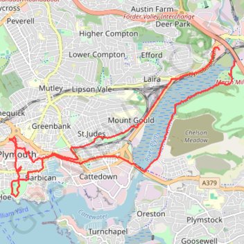
- Distance: 15.7 Km
- Elevation gain: 189 m
- Maximum elevation: 33 m
- Elevation loss: 191 m
- Minimum elevation: 0 m
Interactive trail map
Trail profile
- Distance: 15.7 Km
- Elevation gain: 189 m
- Maximum elevation: 33 m
- Elevation loss: 191 m
- Minimum elevation: 0 m
About this trail
Name: Saltram, Chelson Meadow, Prince Rock, Tothill trail, distance, elevation, map, profile, GPS track
End: Plymouth Road, Underwood, Plympton, Plymouth, England, PL3 6RW, United Kingdom (50.38955 -4.08700)
Coordinates: 50.36401 -4.14438 50.38996 -4.08275
Other hiking, mountain biking, running and outdoor activity trails
Click on a trail to view its statistics, map and profile.
Forder Valley and Efford Marsh
United Kingdom > England > Plymouth
Distance: 7.3 Km • Elevation gain: 166 m • Maximum elevation: 70 m
Plymouth eBike ride
United Kingdom > England > Plymouth
Distance: 43.3 Km • Elevation gain: 798 m • Maximum elevation: 116 m
Central Park
United Kingdom > England > Plymouth > Crownhill
Distance: 1.8 Km • Elevation gain: 14 m • Maximum elevation: 63 m
Mutley Park, Thorn Park
United Kingdom > England > Plymouth
Distance: 0.8 Km • Elevation gain: 29 m • Maximum elevation: 99 m