Import a GPX file

Tour from Jack White to SE Military w/ diversion to new Emory Oaks Trailhead

  • Distance: 47.5 Km
  • Elevation gain: 221 m
  • Maximum elevation: 223 m
  • Elevation loss: 221 m
  • Minimum elevation: 167 m
  • Moving time: 2 h 57 m
  • Moving speed: 16.1 Km/h
  • Maximum speed: 35.7 Km/h
  • Total time: 3 h 40 m
  • Global speed: 12.9 Km/h

Interactive trail map

Trail profile

  • Distance: 47.5 Km
  • Elevation gain: 221 m
  • Maximum elevation: 223 m
  • Elevation loss: 221 m
  • Minimum elevation: 167 m
  • Moving time: 2 h 57 m
  • Moving speed: 16.1 Km/h
  • Maximum speed: 35.7 Km/h
  • Total time: 3 h 40 m
  • Global speed: 12.9 Km/h

About this trail

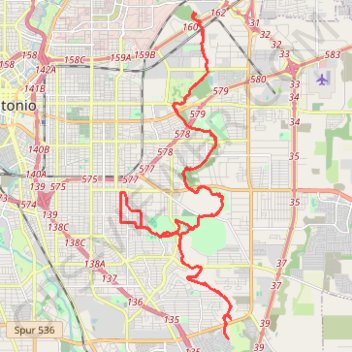
Name: Tour from Jack White to SE Military w/ diversion to new Emory Oaks Trailhead trail, distance, elevation, map, profile, GPS track

Start: Salado Creek Greenway Trail, San Antonio, Bexar County, Texas, 78234, United States (29.45228 -98.42395)

End: Salado Creek Greenway Trail, San Antonio, Bexar County, Texas, 78234, United States (29.45239 -98.42379)

Coordinates: 29.35231 -98.45043 29.45276 -98.41135

Gear up for your next adventure:

📦Crushproof Equipment Cases - Safe transport for sensitive surveying and mapping instruments
📕Australia Maps - Maps covering Australian regions
🐍Australian Snake Bite Kits - Specific pressure immobilization bandages for Australian venomous snakes
🩹Blister Prevention Tape - Apply to friction points before they become painful sores
📱Shockproof Phone Cases - Extra protection for your smartphone against drops on rocky terrain

As an Amazon Associate, this site earns from qualifying purchases at no extra cost to you.