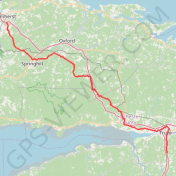
Amherst - Brookfield
- Distance: 121.3 Km
- Elevation gain: 1,019 m
- Maximum elevation: 255 m
- Elevation loss: 981 m
- Minimum elevation: 6 m
Interactive trail map
Trail profile
- Distance: 121.3 Km
- Elevation gain: 1,019 m
- Maximum elevation: 255 m
- Elevation loss: 981 m
- Minimum elevation: 6 m
About this trail
Name: Amherst - Brookfield trail, distance, elevation, map, profile, GPS track
Coordinates: 45.28600 -64.20230 45.80261 -63.27682
Other hiking, mountain biking, running and outdoor activity trails
Click on a trail to view its statistics, map and profile.
Pictou - Brookfield
Canada > Nova Scotia > Town of Pictou > Pictou
#Bike #Pictou #Brookfield
Distance: 71.5 Km • Elevation gain: 535 m • Maximum elevation: 208 m
Wentworth Festival of Colors
Canada > Nova Scotia > Municipality of the County of Cumberland > Wentworth Station
Hiked to High Head and Down Mountain.
Distance: 6.9 Km • Elevation gain: 287 m • Maximum elevation: 296 m