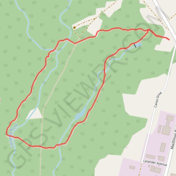
Mi'Kmawey Interpretive Trail
Interactive trail map
Trail profile
- Distance: 4.2 Km
- Elevation gain: 30 m
- Maximum elevation: 33 m
- Elevation loss: 30 m
- Minimum elevation: 23 m
About this trail
Name: Mi'Kmawey Interpretive Trail trail, distance, elevation, map, profile, GPS track
Coordinates: 45.40452 -63.44535 45.41413 -63.42676
Other hiking, mountain biking, running and outdoor activity trails
Click on a trail to view its statistics, map and profile.
Amherst - Brookfield
Canada > Nova Scotia > Municipality of the County of Cumberland > Upper Nappan
Distance: 121.3 Km • Elevation gain: 1,019 m • Maximum elevation: 255 m