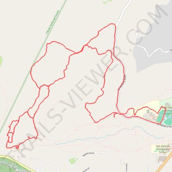
Campbell Ranch
- Distance: 14.3 Km
- Elevation gain: 314 m
- Maximum elevation: 2,189 m
- Elevation loss: 314 m
- Minimum elevation: 2,063 m
Interactive trail map
Trail profile
- Distance: 14.3 Km
- Elevation gain: 314 m
- Maximum elevation: 2,189 m
- Elevation loss: 314 m
- Minimum elevation: 2,063 m
About this trail
Name: Campbell Ranch trail, distance, elevation, map, profile, GPS track
Coordinates: 35.17102 -106.36818 35.18825 -106.34132
Other hiking, mountain biking, running and outdoor activity trails
Click on a trail to view its statistics, map and profile.
Campbell Scout Camp
United States > New Mexico > Bernalillo County
Distance: 21.5 Km • Elevation gain: 463 m • Maximum elevation: 2,227 m