Make a donation
Gear up for your next adventure:
As an Amazon Associate, this site earns from qualifying purchases at no extra cost to you.
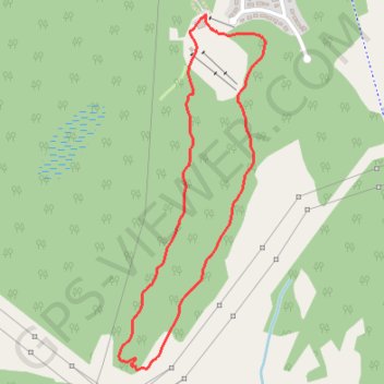
Batawa Trails
#Hiking #MTB #Snowshoeing #Loop
- Distance: 3.1 Km
- Elevation gain: 70 m
- Maximum elevation: 153 m
- Elevation loss: 70 m
- Minimum elevation: 104 m
Interactive trail map
Make a donation
Gear up for your next adventure:
As an Amazon Associate, this site earns from qualifying purchases at no extra cost to you.
Trail profile
- Distance: 3.1 Km
- Elevation gain: 70 m
- Maximum elevation: 153 m
- Elevation loss: 70 m
- Minimum elevation: 104 m
Make a donation
Gear up for your next adventure:
As an Amazon Associate, this site earns from qualifying purchases at no extra cost to you.
About this trail
Name: Batawa Trails trail, distance, elevation, map, profile, GPS track
Start: Dino Dig, Batawa, Quinte West, Central Ontario, Ontario, K0K 1E0, Canada (44.16702 -77.59670)
End: Dino Dig, Batawa, Quinte West, Central Ontario, Ontario, K0K 1E0, Canada (44.16702 -77.59670)
Coordinates: 44.15582 -77.60051 44.16702 -77.59408
Make a donation
Gear up for your next adventure:
As an Amazon Associate, this site earns from qualifying purchases at no extra cost to you.
Other hiking, mountain biking, running and outdoor activity trails
Click on a trail to view its statistics, map and profile.
Cobourg - Belleville
Canada > Ontario > Northumberland County > Cobourg
#Bike
Distance: 81.5 Km • Elevation gain: 286 m • Maximum elevation: 118 m