Import a GPX file

Horseshoe Mesa (Grand Canyon)

Hike on the Grandview Trail to Horseshoe Mesa in the Grand Canyon National Park. #Hiking #Canyon #Mountain #Nature #Forest #Park

  • Distance: 4.5 Km
  • Elevation gain: 131 m
  • Maximum elevation: 2,257 m
  • Elevation loss: 896 m
  • Minimum elevation: 1,490 m

Interactive trail map
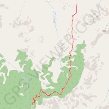
Trail profile

  • Distance: 4.5 Km
  • Elevation gain: 131 m
  • Maximum elevation: 2,257 m
  • Elevation loss: 896 m
  • Minimum elevation: 1,490 m

About this trail

Name: Horseshoe Mesa (Grand Canyon) trail, distance, elevation, map, profile, GPS track

Start: Grandview Trail, Coconino County, Arizona, United States (35.99803 -111.98778)

End: Grandview Trail, Coconino County, Arizona, United States (36.02030 -111.97591)

Coordinates: 35.99803 -111.98783 36.02030 -111.97567

Other hiking, mountain biking, running and outdoor activity trails

Click on a trail to view its statistics, map and profile.

Grandview Trail (Grand Canyon)

United States > Arizona > Coconino County

Hike along the Grandview Trail from Grandview Point in the Grand Canyon National Park. #Hiking #Canyon #Mountain #Nature #Rock #River #Park

Distance: 13.8 Km • Elevation gain: 1,150 m • Maximum elevation: 2,254 m

Gear up for your next adventure:

🛌Sleeping Bags - Sleeping bags for outdoor camping
🎒Hiking Backpacks - Backpacks designed for hiking and trekking
🧤Thermal Hiking Gloves - Keep your hands warm and functional during high-altitude winter treks
🎧Bluetooth Outdoor Earbuds - Listen to navigation cues or podcasts during long solo treks
📕Australia Maps - Maps covering Australian regions

As an Amazon Associate, this site earns from qualifying purchases at no extra cost to you.