Thank you for supporting this site ❤️
Make a donation
Make a donation
Gear up for your next adventure:
⌚Altimeter Barometer Watches - Outdoor watches with built-in sensors to track altitude changes and weather shifts
As an Amazon Associate, this site earns from qualifying purchases at no extra cost to you.
Glen Luce - Glenlyon
#MTB
- Distance: 20.7 Km
- Elevation gain: 495 m
- Maximum elevation: 564 m
- Elevation loss: 298 m
- Minimum elevation: 326 m
Interactive trail map
Thank you for supporting this site ❤️
Make a donation
Make a donation
Gear up for your next adventure:
As an Amazon Associate, this site earns from qualifying purchases at no extra cost to you.
Trail profile
- Distance: 20.7 Km
- Elevation gain: 495 m
- Maximum elevation: 564 m
- Elevation loss: 298 m
- Minimum elevation: 326 m
Thank you for supporting this site ❤️
Make a donation
Make a donation
Gear up for your next adventure:
As an Amazon Associate, this site earns from qualifying purchases at no extra cost to you.
About this trail
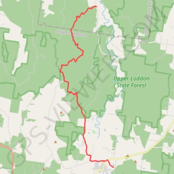
Name: Glen Luce - Glenlyon trail, distance, elevation, map, profile, GPS track
End: Pony Club Road, Glenlyon, Shire of Hepburn, Victoria, 3461, Australia (-37.29752 144.25335)
Coordinates: -37.29752 144.20519 -37.18260 144.25335
Topography: Victoria topographic map, elevation, terrain
Thank you for supporting this site ❤️
Make a donation
Make a donation
Gear up for your next adventure:
As an Amazon Associate, this site earns from qualifying purchases at no extra cost to you.
Other hiking, mountain biking, running and outdoor activity trails
Click on a trail to view its statistics, map and profile.