Make a donation
Gear up for your next adventure:
As an Amazon Associate, this site earns from qualifying purchases at no extra cost to you.
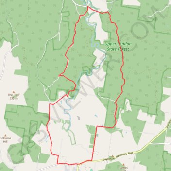
Upper Loddon Circuit
Interactive trail map
Make a donation
Gear up for your next adventure:
As an Amazon Associate, this site earns from qualifying purchases at no extra cost to you.
Trail profile
- Distance: 24.0 Km
- Elevation gain: 423 m
- Maximum elevation: 580 m
- Elevation loss: 423 m
- Minimum elevation: 355 m
Make a donation
Gear up for your next adventure:
As an Amazon Associate, this site earns from qualifying purchases at no extra cost to you.
About this trail
Name: Upper Loddon Circuit trail, distance, elevation, map, profile, GPS track
Start: 37, Ford Street, Glenlyon, Shire of Hepburn, Victoria, 3461, Australia (-37.29315 144.24533)
End: 37, Ford Street, Glenlyon, Shire of Hepburn, Victoria, 3461, Australia (-37.29315 144.24560)
Coordinates: -37.29335 144.22591 -37.21710 144.27318
Topography: Victoria topographic map, elevation, terrain
Make a donation
Gear up for your next adventure:
As an Amazon Associate, this site earns from qualifying purchases at no extra cost to you.
Other hiking, mountain biking, running and outdoor activity trails
Click on a trail to view its statistics, map and profile.
Glen Luce - Glenlyon
Australia > Victoria > Glen Luce
#MTB
Distance: 20.7 Km • Elevation gain: 495 m • Maximum elevation: 564 m