Green Mountain via Gregory Canyon Trail and Ranger Trail
The Green Mountain hike via Gregory Canyon and Ranger Trails offers a moderately challenging journey through varied terrain, with sweeping views of the Boulder Valley and surrounding peaks. Hikers will experience a mix of shaded forest paths, rocky ridgelines, and open meadows, culminating in panoramic vistas from the summit, including distant views of the iconic Longs Peak and the Flatirons. The ascent can be steep and strenuous, but the rewarding scenery and the opportunity to spot wildlife along the way make this a memorable and fulfilling hike. #Hiking #Mountain #Forest #Nature
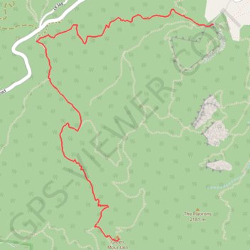
- Distance: 4.4 Km
- Elevation gain: 673 m
- Maximum elevation: 2,449 m
- Elevation loss: 8 m
- Minimum elevation: 1,782 m
Interactive trail map
Trail profile
- Distance: 4.4 Km
- Elevation gain: 673 m
- Maximum elevation: 2,449 m
- Elevation loss: 8 m
- Minimum elevation: 1,782 m
About this trail
Name: Green Mountain via Gregory Canyon Trail and Ranger Trail trail, distance, elevation, map, profile, GPS track
Coordinates: 39.98187 -105.30930 39.99854 -105.29266
Other hiking, mountain biking, running and outdoor activity trails
Click on a trail to view its statistics, map and profile.
Flagstaff Mountain Loop via Gregory Canyon Trail, Range View Trail and Flagstaff Trail
United States > Colorado > Boulder County
The Flagstaff Mountain Loop offers a memorable hiking experience within Boulder’s iconic foothills. Along the route, hikers are treated to sweeping views of the Flatirons, the city of Boulder below, and lush forested areas, especially as the trail ascends towards Flagstaff Mountain. The diverse scenery…
Distance: 6.5 Km • Elevation gain: 377 m • Maximum elevation: 2,117 m
Green Mountain West Ridge Trail in Boulder Open Space and Mountain Parks
United States > Colorado > Boulder County
The Green Mountain West Ridge Trail in Boulder Open Space and Mountain Parks offers a challenging yet rewarding hike with expansive views of the surrounding landscape. Hikers are treated to panoramic vistas of Boulder, the Flatirons, and the expansive Rocky Mountain range, all framed by diverse ecosystems,…
Distance: 6.2 Km • Elevation gain: 239 m • Maximum elevation: 2,449 m