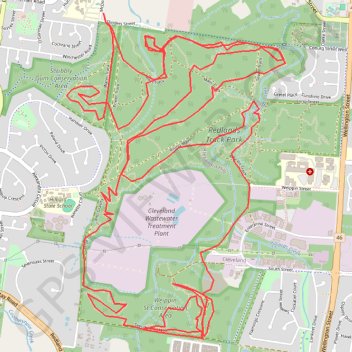
Redlands Track Park
Interactive trail map
Trail profile
- Distance: 21.1 Km
- Elevation gain: 269 m
- Maximum elevation: 60 m
- Elevation loss: 272 m
- Minimum elevation: 16 m
About this trail
Name: Redlands Track Park trail, distance, elevation, map, profile, GPS track
Start: Power Track, Alexandra Hills, Greater Brisbane, Queensland, 4161, Australia (-27.52959 153.23543)
End: McDonald Road, Alexandra Hills, Greater Brisbane, Queensland, 4161, Australia (-27.52889 153.23520)
Coordinates: -27.55239 153.23224 -27.52889 153.25002
Topography: Queensland topographic map, elevation, terrain
Other hiking, mountain biking, running and outdoor activity trails
Click on a trail to view its statistics, map and profile.
Capalaba and Alex Hills loop
Distance: 21.2 Km • Elevation gain: 250 m • Maximum elevation: 57 m