Make a donation
Gear up for your next adventure:
As an Amazon Associate, this site earns from qualifying purchases at no extra cost to you.
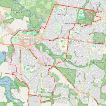
Capalaba and Alex Hills loop
- Distance: 21.2 Km
- Elevation gain: 250 m
- Maximum elevation: 57 m
- Elevation loss: 254 m
- Minimum elevation: 3 m
- Moving time: 2 h 6 m
- Moving speed: 10.1 Km/h
- Maximum speed: 22.0 Km/h
- Total time: 2 h 13 m
- Global speed: 9.6 Km/h
Interactive trail map
Make a donation
Gear up for your next adventure:
As an Amazon Associate, this site earns from qualifying purchases at no extra cost to you.
Trail profile
- Distance: 21.2 Km
- Elevation gain: 250 m
- Maximum elevation: 57 m
- Elevation loss: 254 m
- Minimum elevation: 3 m
- Moving time: 2 h 6 m
- Moving speed: 10.1 Km/h
- Maximum speed: 22.0 Km/h
- Total time: 2 h 13 m
- Global speed: 9.6 Km/h
Make a donation
Gear up for your next adventure:
As an Amazon Associate, this site earns from qualifying purchases at no extra cost to you.
About this trail
Name: Capalaba and Alex Hills loop trail, distance, elevation, map, profile, GPS track
Start: Howlett Road, Capalaba, Greater Brisbane, Queensland, 4157, Australia (-27.53879 153.18096)
End: Howlett Road, Capalaba, Greater Brisbane, Queensland, 4157, Australia (-27.53881 153.18152)
Coordinates: -27.55278 153.18096 -27.50508 153.23373
Topography: Queensland topographic map, elevation, terrain
Make a donation
Gear up for your next adventure:
As an Amazon Associate, this site earns from qualifying purchases at no extra cost to you.
Other hiking, mountain biking, running and outdoor activity trails
Click on a trail to view its statistics, map and profile.
Loop to Capalaba Regional Park
Distance: 10.7 Km • Elevation gain: 130 m • Maximum elevation: 57 m