Thank you for supporting this site ❤️
Make a donation
Make a donation
Gear up for your next adventure:
As an Amazon Associate, this site earns from qualifying purchases at no extra cost to you.
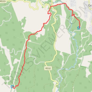
Fanie Botha Mac Mac Hut to Graskop Hut
- Distance: 12.6 Km
- Elevation gain: 280 m
- Maximum elevation: 1,635 m
- Elevation loss: 469 m
- Minimum elevation: 1,371 m
- Moving time: 3 h 2 m
- Moving speed: 4.1 Km/h
- Maximum speed: 6.2 Km/h
- Total time: 4 h 48 m
- Global speed: 2.6 Km/h
Interactive trail map
Thank you for supporting this site ❤️
Make a donation
Make a donation
Gear up for your next adventure:
As an Amazon Associate, this site earns from qualifying purchases at no extra cost to you.
Trail profile
- Distance: 12.6 Km
- Elevation gain: 280 m
- Maximum elevation: 1,635 m
- Elevation loss: 469 m
- Minimum elevation: 1,371 m
- Moving time: 3 h 2 m
- Moving speed: 4.1 Km/h
- Maximum speed: 6.2 Km/h
- Total time: 4 h 48 m
- Global speed: 2.6 Km/h
Thank you for supporting this site ❤️
Make a donation
Make a donation
Gear up for your next adventure:
As an Amazon Associate, this site earns from qualifying purchases at no extra cost to you.
About this trail
Name: Fanie Botha Mac Mac Hut to Graskop Hut trail, distance, elevation, map, profile, GPS track
Coordinates: -24.98719 30.78057 -24.92991 30.83068
Thank you for supporting this site ❤️
Make a donation
Make a donation
Gear up for your next adventure:
🐍Australian Snake Bite Kits - Specific pressure immobilization bandages for Australian venomous snakes
As an Amazon Associate, this site earns from qualifying purchases at no extra cost to you.
Other hiking, mountain biking, running and outdoor activity trails
Click on a trail to view its statistics, map and profile.
Fanie Botha Stables Hut to Mac Mac Hut via Mount Moodie
South Africa > Mpumalanga > Ehlanzeni District Municipality > Thaba Chweu Local Municipality > Mount Anderson
Distance: 16.5 Km • Elevation gain: 717 m • Maximum elevation: 2,058 m