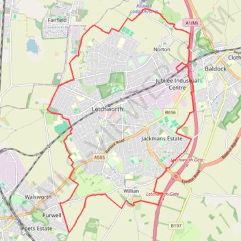
Letchworth Greenway
Route created on plotaroute.com
- Distance: 20.5 Km
- Elevation gain: 161 m
- Maximum elevation: 108 m
- Elevation loss: 161 m
- Minimum elevation: 57 m
- Moving time: 4 h 6 m
- Moving speed: 5.0 Km/h
- Maximum speed: 5.5 Km/h
- Total time: 4 h 6 m
- Global speed: 5.0 Km/h
Interactive trail map
Trail profile
- Distance: 20.5 Km
- Elevation gain: 161 m
- Maximum elevation: 108 m
- Elevation loss: 161 m
- Minimum elevation: 57 m
- Moving time: 4 h 6 m
- Moving speed: 5.0 Km/h
- Maximum speed: 5.5 Km/h
- Total time: 4 h 6 m
- Global speed: 5.0 Km/h
About this trail
Name: Letchworth Greenway trail, distance, elevation, map, profile, GPS track
End: Willian, North Hertfordshire, Hertfordshire, England, SG6 2AH, United Kingdom (51.95679 -0.21939)
Coordinates: 51.95063 -0.25246 52.00295 -0.19646
Other hiking, mountain biking, running and outdoor activity trails
Click on a trail to view its statistics, map and profile.
Hitchin Outer Orbital Path (HOOP)
United Kingdom > England > Hertfordshire > North Hertfordshire > Hitchin
Distance: 19.1 Km • Elevation gain: 176 m • Maximum elevation: 100 m
Deacon Hill
United Kingdom > England > Hertfordshire > North Hertfordshire
Letchworth, Ickleford, Pirton, Deacon Hill and return
Distance: 26.5 Km • Elevation gain: 293 m • Maximum elevation: 182 m
From Royston to Letchworth
United Kingdom > England > Hertfordshire > North Hertfordshire > Royston
Distance: 23.6 Km • Elevation gain: 260 m • Maximum elevation: 168 m