Hitchin Outer Orbital Path (HOOP)
- Distance: 19.1 Km
- Elevation gain: 176 m
- Maximum elevation: 100 m
- Elevation loss: 176 m
- Minimum elevation: 51 m
- Moving time: 5 h 2 m
- Moving speed: 3.8 Km/h
- Maximum speed: 6.0 Km/h
- Total time: 5 h 2 m
- Global speed: 3.8 Km/h
Interactive trail map
Trail profile
- Distance: 19.1 Km
- Elevation gain: 176 m
- Maximum elevation: 100 m
- Elevation loss: 176 m
- Minimum elevation: 51 m
- Moving time: 5 h 2 m
- Moving speed: 3.8 Km/h
- Maximum speed: 6.0 Km/h
- Total time: 5 h 2 m
- Global speed: 3.8 Km/h
About this trail
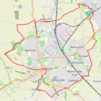
Name: Hitchin Outer Orbital Path (HOOP) trail, distance, elevation, map, profile, GPS track
Coordinates: 51.93505 -0.31153 51.97937 -0.24058
Other hiking, mountain biking, running and outdoor activity trails
Click on a trail to view its statistics, map and profile.
Deacon Hill
United Kingdom > England > Hertfordshire > North Hertfordshire
Letchworth, Ickleford, Pirton, Deacon Hill and return
Distance: 26.5 Km • Elevation gain: 293 m • Maximum elevation: 182 m
Letchworth Greenway
United Kingdom > England > Hertfordshire > North Hertfordshire > Willian
Route created on plotaroute.com
Distance: 20.5 Km • Elevation gain: 161 m • Maximum elevation: 108 m
North Chilterns 50k 2022
United Kingdom > England > Hertfordshire > North Hertfordshire > Offley > Mangrove Green
Distance: 49.9 Km • Elevation gain: 765 m • Maximum elevation: 192 m