Import a GPX file

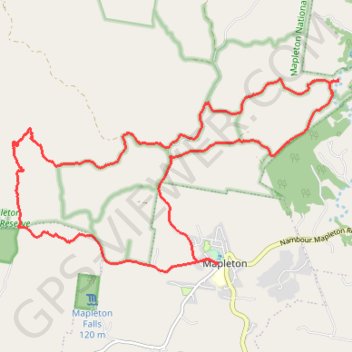
Mapleton - Gheerulla Falls

Mapleton National Park. #MTB #Loop #Mapleton #Gheerulla

  • Distance: 23.2 Km
  • Elevation gain: 681 m
  • Maximum elevation: 454 m
  • Elevation loss: 682 m
  • Minimum elevation: 202 m

Interactive trail map

Trail profile

  • Distance: 23.2 Km
  • Elevation gain: 681 m
  • Maximum elevation: 454 m
  • Elevation loss: 682 m
  • Minimum elevation: 202 m

About this trail

Other hiking, mountain biking, running and outdoor activity trails

Click on a trail to view its statistics, map and profile.

Gheerulla Falls - Mapleton National Park

Australia > Queensland > Sunshine Coast Regional

#Hiking #Mapleton

Distance: 13.2 Km • Elevation gain: 339 m • Maximum elevation: 457 m

Cedar Creek - Gheerulla

Australia > Queensland > Sunshine Coast Regional

Mapleton National Park. #MTB #Loop #Mapleton

Distance: 34.2 Km • Elevation gain: 743 m • Maximum elevation: 464 m

Obi Lookout - Cambroon

Australia > Queensland > Sunshine Coast Regional

#MTB #Loop

Distance: 63.8 Km • Elevation gain: 1,648 m • Maximum elevation: 520 m

Imbil Jimna Kenilworth loop

Australia > Queensland > Tewantin

Distance: 216.0 Km • Elevation gain: 3,884 m • Maximum elevation: 822 m

Gear up for your next adventure:

📣High-Decibel Survival Whistles - Signaling tool for rescue that carries much further than a human voice
Ultralight Solo Tents - Compact shelters for multi-day topographic surveying expeditions
📱Tablet Tripod Mounts - Steady platforms for viewing digital maps or taking long exposures
📡Weather Radios - Emergency weather radios
🪑Portable Backpacking Chairs - A comfortable seat for studying maps at the end of the day

As an Amazon Associate, this site earns from qualifying purchases at no extra cost to you.