Import a GPX file

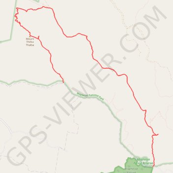
Gheerulla Falls - Mapleton National Park

#Hiking #Mapleton

  • Distance: 13.2 Km
  • Elevation gain: 339 m
  • Maximum elevation: 457 m
  • Elevation loss: 467 m
  • Minimum elevation: 110 m

Interactive trail map

Trail profile

  • Distance: 13.2 Km
  • Elevation gain: 339 m
  • Maximum elevation: 457 m
  • Elevation loss: 467 m
  • Minimum elevation: 110 m
👉 Easily get elevation data in JSON, GeoTIFF and KML formats using Elevation API
Thank you for supporting this site ❤️
Make a donation

Gear up for your next adventure:

As an Amazon Associate, this site earns from qualifying purchases at no extra cost to you.

About this trail

Other hiking, mountain biking, running and outdoor activity trails

Click on a trail to view its statistics, map and profile.

Mapleton - Gheerulla Falls

Australia > Queensland > Sunshine Coast Regional

Mapleton National Park. #MTB #Loop #Mapleton #Gheerulla

Distance: 23.2 Km • Elevation gain: 681 m • Maximum elevation: 454 m

Cedar Creek - Gheerulla

Australia > Queensland > Sunshine Coast Regional

Mapleton National Park. #MTB #Loop #Mapleton

Distance: 34.2 Km • Elevation gain: 743 m • Maximum elevation: 464 m

Obi Lookout - Cambroon

Australia > Queensland > Sunshine Coast Regional

#MTB #Loop

Distance: 63.8 Km • Elevation gain: 1,648 m • Maximum elevation: 520 m

Imbil Jimna Kenilworth loop

Australia > Queensland > Tewantin

Distance: 216.0 Km • Elevation gain: 3,884 m • Maximum elevation: 822 m

Gear up for your next adventure:

🪫Rechargeable Headlamps - USB rechargeable headlamps
🧥Down Jackets - Insulated jackets for cold weather
🕯️Emergency Whistles - Safety whistles for hiking
🪑Portable Backpacking Chairs - A comfortable seat for studying maps at the end of the day
💡Collapsible Camping Lanterns - Illuminate your base camp or tent for map studying at night

As an Amazon Associate, this site earns from qualifying purchases at no extra cost to you.