Import a GPX file

Goat Creek Trail

Spray Valley Provincial Park. Banff National Park. #Hiking #MTB #Snowshoeing #Ski #SprayValley #Banff
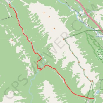
  • Distance: 37.4 Km
  • Elevation gain: 769 m
  • Maximum elevation: 1,668 m
  • Elevation loss: 769 m
  • Minimum elevation: 1,395 m

Interactive trail map

Trail profile

  • Distance: 37.4 Km
  • Elevation gain: 769 m
  • Maximum elevation: 1,668 m
  • Elevation loss: 769 m
  • Minimum elevation: 1,395 m

About this trail

Other hiking, mountain biking, running and outdoor activity trails

Click on a trail to view its statistics, map and profile.

Sulphur Mountain Trail

Canada > Alberta > Improvement District No. 9

Banff National Park. #Hiking #Mountain #Banff #Nature #Forest #Snowshoeing

Distance: 11.0 Km • Elevation gain: 724 m • Maximum elevation: 2,266 m

Bow Falls - Bow River - Banff

Canada > Alberta > Improvement District No. 9

Banff National Park. #Hiking #Trail #Banff

Distance: 7.8 Km • Elevation gain: 261 m • Maximum elevation: 1,563 m

Ha Ling Peak - Miner's Peak

Canada > Alberta > Kananaskis Improvement District

Bow Valley Wildland Provincial Park. #Hiking #HaLing #BowValley

Distance: 7.3 Km • Elevation gain: 916 m • Maximum elevation: 2,479 m

Gear up for your next adventure:

🩹Blister Prevention Tape - Apply to friction points before they become painful sores
🧭Military Style Lensatic Compass - Durable sighting compasses for advanced land navigation and surveying
🍶Collapsible Water Bottles - Save space in your pack as you consume your water supply
🥤Hydration Packs - Hydration systems for hiking
🥾Hiking Shoes - Lightweight hiking shoes for day hikes

As an Amazon Associate, this site earns from qualifying purchases at no extra cost to you.