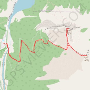
Ha Ling Peak - Miner's Peak
Interactive trail map
Trail profile
- Distance: 7.3 Km
- Elevation gain: 916 m
- Maximum elevation: 2,479 m
- Elevation loss: 916 m
- Minimum elevation: 1,667 m
About this trail
Name: Ha Ling Peak - Miner's Peak trail, distance, elevation, map, profile, GPS track
Coordinates: 51.05815 -115.41850 51.06434 -115.39424
Other hiking, mountain biking, running and outdoor activity trails
Click on a trail to view its statistics, map and profile.
Goat Creek Trail
Canada > Alberta > Kananaskis Improvement District
Spray Valley Provincial Park. Banff National Park. #Hiking #MTB #Snowshoeing #Ski #SprayValley #Banff
Distance: 37.4 Km • Elevation gain: 769 m • Maximum elevation: 1,668 m
Ha Ling Peak
Canada > Alberta > Kananaskis Improvement District
Bow Valley Wildland Provincial Park. #Hiking #Snowshoeing #BowValley
Distance: 7.8 Km • Elevation gain: 817 m • Maximum elevation: 2,473 m