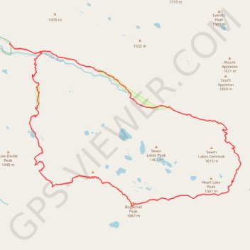
Deer Lake - Bogachiel Peak - Hear Lake
Interactive trail map
Trail profile
- Distance: 28.5 Km
- Elevation gain: 1,521 m
- Maximum elevation: 1,638 m
- Elevation loss: 1,521 m
- Minimum elevation: 591 m
About this trail
Name: Deer Lake - Bogachiel Peak - Hear Lake trail, distance, elevation, map, profile, GPS track
Coordinates: 47.90431 -123.83488 47.95481 -123.72779
Other hiking, mountain biking, running and outdoor activity trails
Click on a trail to view its statistics, map and profile.
Sol Duc Falls Trail in Olympic National Park
United States > Washington > Clallam County
The Sol Duc Falls Trail in Olympic National Park offers an enchanting journey through lush, moss-draped old-growth forests, leading to the stunning Sol Duc Falls, where water cascades gracefully into a narrow gorge. Along the well-maintained path, hikers traverse charming wooden bridges over clear streams and…
Distance: 2.8 Km • Elevation gain: 83 m • Maximum elevation: 635 m
Deer Lake Trail via Sol Duc Falls
United States > Washington > Clallam County
Distance: 4.0 Km • Elevation gain: 369 m • Maximum elevation: 930 m
High Divide Trail
United States > Washington > Clallam County
Distance: 26.4 Km • Elevation gain: 1,359 m • Maximum elevation: 1,643 m