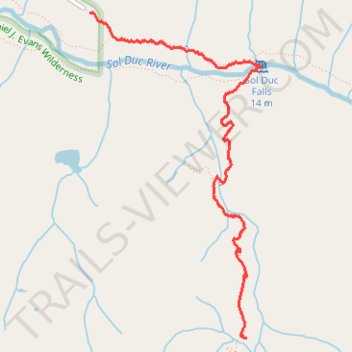
Deer Lake Trail via Sol Duc Falls
- Distance: 4.0 Km
- Elevation gain: 369 m
- Maximum elevation: 930 m
- Elevation loss: 42 m
- Minimum elevation: 592 m
- Moving time: 1 h 9 m
- Moving speed: 3.5 Km/h
- Maximum speed: 10.0 Km/h
- Total time: 1 h 17 m
- Global speed: 3.1 Km/h
Interactive trail map
Trail profile
- Distance: 4.0 Km
- Elevation gain: 369 m
- Maximum elevation: 930 m
- Elevation loss: 42 m
- Minimum elevation: 592 m
- Moving time: 1 h 9 m
- Moving speed: 3.5 Km/h
- Maximum speed: 10.0 Km/h
- Total time: 1 h 17 m
- Global speed: 3.1 Km/h
About this trail
Name: Deer Lake Trail via Sol Duc Falls trail, distance, elevation, map, profile, GPS track
Start: Sol Duc Hot Springs Road, Clallam County, Washington, United States (47.95488 -123.83510)
End: Deer Lake Trail, Clallam County, Washington, United States (47.93548 -123.82114)
Coordinates: 47.93546 -123.83510 47.95490 -123.81989
Other hiking, mountain biking, running and outdoor activity trails
Click on a trail to view its statistics, map and profile.
Sol Duc Falls Trail in Olympic National Park
United States > Washington > Clallam County
The Sol Duc Falls Trail in Olympic National Park offers an enchanting journey through lush, moss-draped old-growth forests, leading to the stunning Sol Duc Falls, where water cascades gracefully into a narrow gorge. Along the well-maintained path, hikers traverse charming wooden bridges over clear streams and…
Distance: 2.8 Km • Elevation gain: 83 m • Maximum elevation: 635 m
High Divide Trail
United States > Washington > Clallam County
Distance: 26.4 Km • Elevation gain: 1,359 m • Maximum elevation: 1,643 m