Make a donation
Gear up for your next adventure:
As an Amazon Associate, this site earns from qualifying purchases at no extra cost to you.
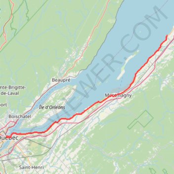
Québec - Saint-Jean-Port-Joli
Saint Lawrence River. #Bike #Québec #SaintJeanPortJoli
- Distance: 95.2 Km
- Elevation gain: 476 m
- Maximum elevation: 82 m
- Elevation loss: 521 m
- Minimum elevation: 0 m
Interactive trail map
Make a donation
Gear up for your next adventure:
As an Amazon Associate, this site earns from qualifying purchases at no extra cost to you.
Trail profile
- Distance: 95.2 Km
- Elevation gain: 476 m
- Maximum elevation: 82 m
- Elevation loss: 521 m
- Minimum elevation: 0 m
Make a donation
Gear up for your next adventure:
As an Amazon Associate, this site earns from qualifying purchases at no extra cost to you.
About this trail
Name: Québec - Saint-Jean-Port-Joli trail, distance, elevation, map, profile, GPS track
Coordinates: 46.80901 -71.21195 47.21790 -70.26524
Make a donation
Gear up for your next adventure:
As an Amazon Associate, this site earns from qualifying purchases at no extra cost to you.
Other hiking, mountain biking, running and outdoor activity trails
Click on a trail to view its statistics, map and profile.
Saint-Jean-Port-Joli - Rivière-du-Loup
Canada > Quebec > L'Islet (MRC) > Saint-Jean-Port-Joli
Saint Lawrence River. #Bike #SaintJeanPortJoli #RivièreDuLoup #SaintLawrence
Distance: 93.6 Km • Elevation gain: 371 m • Maximum elevation: 58 m
Portneuf - Québec
Canada > Quebec > Portneuf (MRC) > Portneuf
Saint Lawrence River. #Bike #Portneuf #Québec #SaintLawrence
Distance: 66.8 Km • Elevation gain: 547 m • Maximum elevation: 90 m
Trois-Rivières - Québec
Canada > Quebec > Trois-Rivières
#Bike
Distance: 138.5 Km • Elevation gain: 838 m • Maximum elevation: 108 m
Make a donation
Gear up for your next adventure:
As an Amazon Associate, this site earns from qualifying purchases at no extra cost to you.