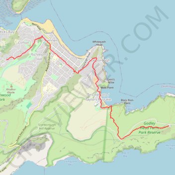
Clifton to Godley Head
Hike from Clifton to Godley Head via Sumner, Scarborough and Taylors Mistake. #Hiking #Nature #Sea #Pacific #Ocean #Coast
- Distance: 8.3 Km
- Elevation gain: 356 m
- Maximum elevation: 218 m
- Elevation loss: 382 m
- Minimum elevation: 4 m
- Moving time: 1 h 46 m
- Moving speed: 4.7 Km/h
- Maximum speed: 10.3 Km/h
- Total time: 1 h 48 m
- Global speed: 4.6 Km/h
Interactive trail map
Trail profile
- Distance: 8.3 Km
- Elevation gain: 356 m
- Maximum elevation: 218 m
- Elevation loss: 382 m
- Minimum elevation: 4 m
- Moving time: 1 h 46 m
- Moving speed: 4.7 Km/h
- Maximum speed: 10.3 Km/h
- Total time: 1 h 48 m
- Global speed: 4.6 Km/h
About this trail
Name: Clifton to Godley Head trail, distance, elevation, map, profile, GPS track
Coordinates: -43.59250 172.74435 -43.56744 172.79848
Other hiking, mountain biking, running and outdoor activity trails
Click on a trail to view its statistics, map and profile.
Lyttelton to Sumner Walk
New Zealand > Canterbury > Christchurch City > Banks Peninsula Community > Lyttelton
Hike from Lyttelton to Sumner via Chalmers Track, Mount Pleasant Bluffs Track, Summit Road and Windsor Castle in the Tauhinu-Korokio Scenic Reserve and the Greenwood Park. #Hiking #Walking #Nature #Mountain #Park #Forest #Sea #Pacific #Ocean
Distance: 7.1 Km • Elevation gain: 411 m • Maximum elevation: 418 m
Godley Head Walkway, Awaroa-Godley Head Loop Track and Crater Rim Walkway hike
New Zealand > Canterbury > Christchurch City > Christchurch
Distance: 8.9 Km • Elevation gain: 418 m • Maximum elevation: 204 m