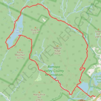
Loop Hike to Bear Swamp Lake in Ramapo Valley County Reservation
- Distance: 11.8 Km
- Elevation gain: 350 m
- Maximum elevation: 269 m
- Elevation loss: 336 m
- Minimum elevation: 69 m
Interactive trail map
Trail profile
- Distance: 11.8 Km
- Elevation gain: 350 m
- Maximum elevation: 269 m
- Elevation loss: 336 m
- Minimum elevation: 69 m
About this trail
Name: Loop Hike to Bear Swamp Lake in Ramapo Valley County Reservation trail, distance, elevation, map, profile, GPS track
Coordinates: 41.07795 -74.22085 41.10475 -74.18669
Other hiking, mountain biking, running and outdoor activity trails
Click on a trail to view its statistics, map and profile.
Ramapo Valley County Reservation Loop Hike: Scarlet Oak Pond, Bald Mountain, Bear Swamp Lake, MacMillan Reservoir
United States > New Jersey > Bergen County > Mahwah > Darlington
Starting from the Darlington side of Ramapo Valley County Reservation, this loop follows Vista Spur Trail toward the Ramapo River before joining Pond Loop Trail beside Scarlet Oak Pond. The route soon leaves the water on Vista Loop, climbing through the forest to Hawk Rock and Cactus Ledge, where open rock…
Distance: 19.4 Km • Elevation gain: 524 m • Maximum elevation: 351 m
Vista Loop Trail via Scarlet Oak Pond, Hawk Rock, Cactus Ledge, Ridge Overlook, MacMillan Reservoir and MacMillan Brook Falls in Ramapo Valley County Reservation
United States > New Jersey > Bergen County > Mahwah > Darlington
This loop provides a scenic hike with varied landscapes, beginning along the serene shores of Scarlet Oak Pond and climbing to viewpoints like Hawk Rock and Cactus Ledge, where sweeping views extend across Bergen County and, on clear days, toward the New York City skyline. This trail is highlighted by its…
Distance: 5.6 Km • Elevation gain: 226 m • Maximum elevation: 250 m
Ringwood State Park
United States > New Jersey > Passaic County > Ringwood > Erskine Lakes
Distance: 12.3 Km • Elevation gain: 309 m • Maximum elevation: 327 m