Circuit de l'ancienne route de Morville
Circuit du Bois des Loups par les Montagnes Noires et l'ancienne route de Morville avec retour par les Faluchamps.
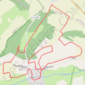
- Distance: 13.2 Km
- Elevation gain: 286 m
- Maximum elevation: 315 m
- Elevation loss: 286 m
- Minimum elevation: 204 m
Interactive trail map
Trail profile
- Distance: 13.2 Km
- Elevation gain: 286 m
- Maximum elevation: 315 m
- Elevation loss: 286 m
- Minimum elevation: 204 m
About this trail
Name: Circuit de l'ancienne route de Morville trail, distance, elevation, map, profile, GPS track
Coordinates: 48.78211 6.51517 48.80547 6.55202
Other hiking, mountain biking, running and outdoor activity trails
Click on a trail to view its statistics, map and profile.
Riethoven naar Oostenrijk
Netherlands > North Brabant > Riethoven > Eind
Distance: 922.1 Km • Elevation gain: 13,629 m • Maximum elevation: 1,897 m
Eurovelo 15 - Strasbourg Rotterdam
France > Grand Est > Bas-Rhin > Strasbourg
Distance: 891.7 Km • Elevation gain: 2,104 m • Maximum elevation: 146 m