Make a donation
Gear up for your next adventure:
As an Amazon Associate, this site earns from qualifying purchases at no extra cost to you.
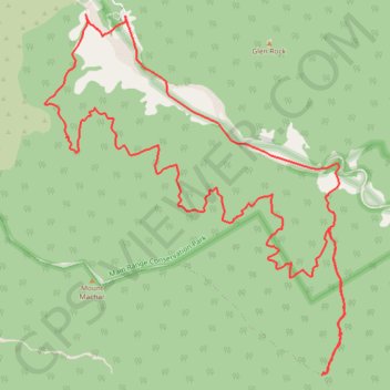
Glen Rock Bottom Yards Loop Track
Interactive trail map
Make a donation
Gear up for your next adventure:
As an Amazon Associate, this site earns from qualifying purchases at no extra cost to you.
Trail profile
- Distance: 19.0 Km
- Elevation gain: 828 m
- Maximum elevation: 882 m
- Elevation loss: 828 m
- Minimum elevation: 333 m
Make a donation
Gear up for your next adventure:
As an Amazon Associate, this site earns from qualifying purchases at no extra cost to you.
About this trail
Name: Glen Rock Bottom Yards Loop Track trail, distance, elevation, map, profile, GPS track
Start: East Haldon, Lockyer Valley Regional, Queensland, Australia (-27.88765 152.24811)
End: East Haldon, Lockyer Valley Regional, Queensland, Australia (-27.88761 152.24810)
Coordinates: -27.92523 152.23862 -27.88744 152.27417
Topography: Queensland topographic map, elevation, terrain
Make a donation
Gear up for your next adventure:
As an Amazon Associate, this site earns from qualifying purchases at no extra cost to you.
Other hiking, mountain biking, running and outdoor activity trails
Click on a trail to view its statistics, map and profile.
Warwick - Gatton
Australia > Queensland > Warwick
#Bike
Distance: 125.3 Km • Elevation gain: 812 m • Maximum elevation: 582 m
Make a donation
Gear up for your next adventure:
As an Amazon Associate, this site earns from qualifying purchases at no extra cost to you.
Walk to Glen Rock, QLD
Distance: 5.0 Km • Elevation gain: 463 m • Maximum elevation: 787 m
Black Duck
Distance: 45.6 Km • Elevation gain: 627 m • Maximum elevation: 569 m